View Spread


The Santa Fe Trail
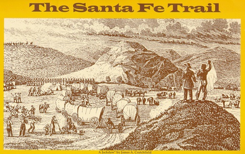
The Santa Fe Trail was America's first great road of commerce west of the Mississippi. Its interesting story reflects the life and times of American involvement in the complex history of what eventually became the southwestern part of the United States. During the early years of the nineteenth century, American merchants attempted, with little success, to open the doors of trade in the Spanish province of New Mexico, far off to the southwest. However, Spanish authorities were suspicious of Americans and wanted no part of them or their wares. In 1821, Mexicans obtained independence from Spain, and almost immediately, they welcomed Americans and their caravans. Between the years 1822 and 1843, more than 3,000 wagons, carrying hundreds of tons of merchandise, worth millions of dollars, made the nearly 800-mile trip between western Missouri and Santa Fe. From escorting wagon trains to protect them from marauding Indians, to marching across the prairie in the conquering "Army of the West" that captured Santa Fe for the Americans in the early days of the Mexican-American War, soldiers plodded across today's states of Missouri, Kansas, Oklahoma, Colorado and New Mexico. This primary source portfolio features facsimiles of historical maps, old engravings, and documents, most often reproduced in their original size. It provides students, teachers, and history buffs with a fascinating experience. This portfolio includes a Study Guide with reproducible student activities and a timeline of trail history from 1821 to 1987. 5 Illustrated Broadsheet Essays: * The Mystery of Santa Fe * William Becknell and the Santa Fe Trail * Freighting on The Santa Fe Trail * Josiah Gregg: Chronicler of Trail Life * Demise of the Santa Fe Trail 12 Primary Source Documents: * Map showing path of Santa Fe Trail over present-day states * Plan of Santa Fe, c. 1840 * Engraving of Santa Fe, 1846 * Contemporary advertising broadside for Josiah Gregg's Commerce of the Prairies * Josiah Gregg's "Map of the Indian Territory, Northern Texas and New Mexico Showing the Great Western Prairies," 1844 * Josiah Gregg's Table of Distances between Independence, Mo. and Santa Fe, N.M., 1844 and Josiah Gregg's Statistical Table, 1844 * Plan of Bent's Fort, 1845 * Expedition recruitment notice, 1825 * Illustration depicting wagon train with military escort * Pages from Colonel Stephen Watts Kearny's Laws of the Territory of New Mexico, 1846 * Illustration showing switchback rails at Raton Pass * Lithograph of City of Santa Fe, 1883